Région Poitou-Charentes
La région du Poitou-Charentes porte le numéro 54 et est composée de 4 département(s) , 14 arrondissement(s) , 157 cantons et 1462 communes. Plus bas vous trouverez la carte du Poitou-Charentes.
Population du Poitou-Charentes
Les habitants du Poitou-Charentes étaient au nombre de 1 640 068 au recensement de 1999 et de 1 724 123 au recensement de 2006. La superficie de la région du Poitou-Charentes est de 25 809,53 km ². La densité de population de la région du Poitou-Charentes est de 66,80 habitants par km².
Les plus grandes villes de la region du Poitou-Charentes en nombre d'habitants par rapport au recensement de 2007 sont: Poitiers (86), La Rochelle (17), Niort (79), Angoulême (16), Châtellerault (86), Saintes (17), Rochefort (17), Cognac (16), Bressuire (79), Royan (17), Parthenay (79), Soyaux (16), Thouars (79), Buxerolles (86), Aytré (17), Mauléon (79), Saint-Maixent-l'École (79), Ruelle-sur-Touvre (16), Saint-Jean-d'Angély (17), Tonnay-Charente (17), Loudun (86), Lagord (17), La Couronne (16).
La liste complète des communes de la région Poitou-Charentes est affichée en bas de page. Vous pourrez consulter la carte de france, les photos, et les informations de chaque ville et village de la région Poitou-Charentes.
J'aime la région Poitou-Charentes !
Les plus grandes villes du Poitou-Charentes
| Noms des villes principales du Poitou-Charentes |
recensement (hab 2007) |
Surface (km ²) |
Densité (hab/km²) |
Altitude (m) |
| Poitiers (86) | 89 253 | 42.11 | 2 119.52 | 116 m |
| La Rochelle (17) | 76 848 | 28.43 | 2 703.06 | 10 m |
| Niort (79) | 58 576 | 68.20 | 858.89 | 28 m |
| Angoulême (16) | 42 669 | 21.85 | 1 952.81 | 86 m |
| Châtellerault (86) | 33 993 | 51.93 | 654.59 | 52 m |
| Saintes (17) | 26 401 | 45.55 | 579.60 | 20 m |
| Rochefort (17) | 25 999 | 21.95 | 1 184.46 | 10 m |
| Cognac (16) | 19 243 | 15.50 | 1 241.48 | 21 m |
| Bressuire (79) | 18 436 | 180.59 | 102.09 | 182 m |
| Royan (17) | 18 424 | 19.30 | 954.61 | 5 m |
| Parthenay (79) | 10 415 | 11.38 | 915.20 | 169 m |
| Soyaux (16) | 10 348 | 12.76 | 810.97 | 130 m |
| Thouars (79) | 9 928 | 12.09 | 821.17 | 90 m |
| Buxerolles (86) | 9 679 | 9.10 | 1 063.63 | 110 m |
| Aytré (17) | 8 806 | 12.22 | 720.62 | 10 m |
| Mauléon (79) | 7 885 | 120.64 | 65.36 | 150 m |
| Saint-Maixent-l'École (79) | 7 590 | 5.22 | 1 454.02 | 60 m |
| Ruelle-sur-Touvre (16) | 7 468 | 10.66 | 700.56 | 45 m |
| Saint-Jean-d'Angély (17) | 7 463 | 18.78 | 397.39 | 20 m |
| Tonnay-Charente (17) | 7 434 | 34.39 | 216.17 | 10 m |
| Loudun (86) | 7 173 | 43.77 | 163.88 | 88 m |
| Lagord (17) | 7 054 | 8.04 | 877.36 | 20 m |
| La Couronne (16) | 7 037 | 28.82 | 244.17 | 60 m |
Statistiques de la région du Poitou-Charentes
| Population 1999 | 1 640 068 habitants | |
|---|---|---|
| Population 2006 | 1 724 123 habitants | |
| Superficie | 25 809.53 km ² | |
| Densité de population | 66.80 habs/km² |
|
| Variation de densité | +0.72 % |
|
Administration de la région du Poitou-Charentes
| Numéro | 54 | |
|---|---|---|
| Préfecture | Poitiers | |
| Chefs-lieux |
Angoulême La Rochelle Niort Poitiers |
|
| Départements |
Charente (16) Charente-Maritime (17) Deux-Sèvres (79) Vienne (86) |
|
Subdivisions de la région du Poitou-Charentes
| Départements | 4 | |
|---|---|---|
| Arrondissements | 14 | |
| Cantons | 157 | |
| Communes | 1462 | |
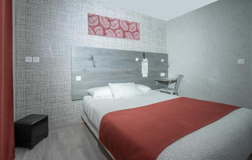
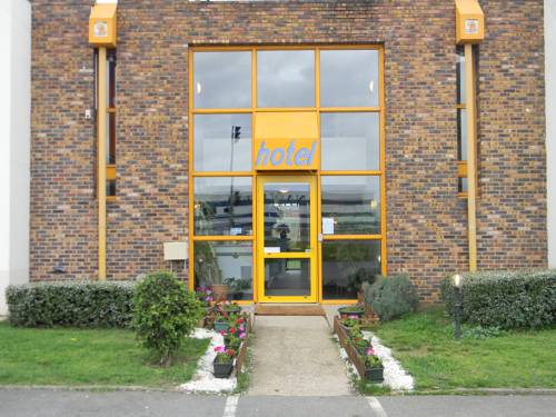
Hotel Poitou-Charentes
Réservez dès aujourd'hui au meilleur prix, sans frais de réservation et sans frais d'annulation
grâce à notre partenaire Booking.com, leader dans la réservation d'hôtels en ligne.

Angoulême : Sure Hotel by Best Western Angouleme
")

Bien: 7.5 / 10 (868 avis)
Situé à Angoulême, l’établissement Sure Hotel by Best Western Angouleme comprend une salle de sport, un salon commun, une terrasse et un bar. Cet hôtel 3 étoiles propose une bagagerie ...

ibis budget Angoulême Centre
Bien: 7.4 / 10 (1253 avis)
Prix: de 36.90 € à
56.00 €
Cet hôtel est situé dans le centre d'Angoulême, à seulement 200 mètres de la gare et de la vieille ville. Ses chambres avec salle de bains privative comprennent une connexion Wi-Fi gra...
La Rochelle : Hôtel Le Rupella
Agréable: 7 / 10 (1171 avis)
Tarifs: de 56.70 € à
103.50 €
Situé au cœur de La Rochelle, l'Hôtel Le Rupella propose des chambres avec salle de bains privative, connexion Wi-Fi gratuite et bureau, à 10 minutes à pied de la gare et à proximité d...

La Rochelle : Hotel de La Paix
Bien: 7.3 / 10 (940 avis)
Tarif: de 52.00 € à
119.00 €
Au cœur de la ville historique, à 2 pas du Vieux Port de La Rochelle, l'hôtel vous accueille dans une authentique maison d’armateur du XVIIIème siècle.
Entre le marché et la place d...
Niort : France Hôtel
Superbe: 9.2 / 10 (373 avis)
Prix: de 61.00 € à
109.00 €
Le France Hôtel est idéalement situé au cœur du centre-ville de Niort, dans un quartier piétonnier très calme, parfait pour un séjour relaxant.
Cet établissement propose des chambres ...

Brit Hôtel du Parc Niort Centre-Parking gratuit
Bien: 7.9 / 10 (1112 avis)
Tarifs: de 65.00 € à
95.00 €
500m du centre ville de Niort. Hôtel 3 étoiles avec un bar ou une terrasse où vous pourrez vous détendre.
L'hôtel dispose d'un parking privé, sécurisé et gratuit.
Toutes les chambres...
Poitiers : Hôtel Mac Bed
Très bien: 8.4 / 10 (2073 avis)
Tarif: de 57.00 € à
63.00 €
Mac Bed is located between Poitiers and the Futuroscope Centre, and provides low-cost accommodation in northern Poitou. Free Wi-Fi is available throughout the hotel.
Each Mac Bed room...
Poitiers : Class-Hôtel
Passable: 5.1 / 10 (380 avis)
Prix: à partir de 40.00 €
Le Class-Hôtel est situé à Poitiers, à 10 minutes en voiture du centre-ville et à 1 km de l'autoroute A10. Il vous propose un hébergement doté d'une connexion Wi-Fi gratuite.
Toutes l...
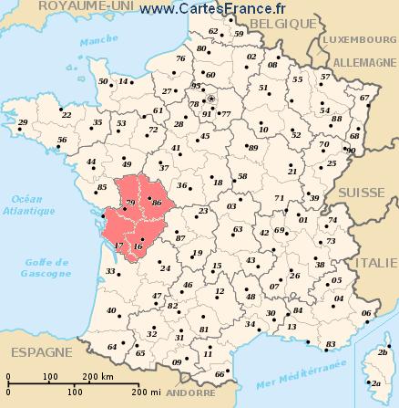
Carte du Poitou-Charentes
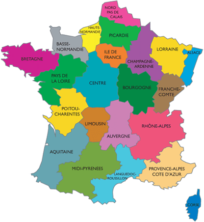
Ou est située la région du Poitou-Charentes ?
La région du Poitou-Charentes est située à l'ouest de la France. La localisation du Poitou-Charentes est visible en rouge sur la carte des régions de france.
Quelles sont les statistiques et les chiffres clés du Poitou-Charentes ?
La région du Poitou-Charentes porte le numéro 54 et est composée de 4 départements , 14 arrondissements, 157 cantons et 1462 communes.
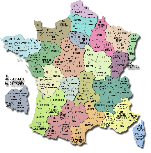
Les 4 departements de la region du Poitou-Charentes sont: Charente (16), Charente-Maritime (17), Deux-Sèvres (79), Vienne (86)
Les habitants du Poitou-Charentes étaient au nombre de 1 640 068 au recensement de 1999 et de 1 724 123 au recensement de 2006. La superficie de la region du Poitou-Charentes est de 25 809,53 km ². La densité de population de la region du Poitou-Charentes est de 66,80 habitants par km².
Quelles sont les principales villes de la region du Poitou-Charentes ?
Les plus grandes villes de la region du Poitou-Charentes en nombre d'habitants par rapport au recensement de 2007 sont: Poitiers (86), La Rochelle (17), Niort (79), Angoulême (16), Châtellerault (86), Saintes (17), Rochefort (17), Cognac (16), Bressuire (79), Royan (17), Parthenay (79), Soyaux (16), Thouars (79), Buxerolles (86), Aytré (17), Mauléon (79), Saint-Maixent-l'École (79), Ruelle-sur-Touvre (16), Saint-Jean-d'Angély (17), Tonnay-Charente (17), Loudun (86), Lagord (17), La Couronne (16).
Carte de France interactive de la région du Poitou-Charentes
Vous pouvez zoomer sur cette carte satellite pour voir la carte routière du Poitou-Charentes ou une ville ou un village en particulier, par exemple Poitiers.
Rechercher une commune de la région du Poitou-Charentes
CARTE DE LA REGION POITOU-CHARENTES
Région Poitou-Charentes : le saviez-vous ?
La commune possédant le nom le plus long de la région du Poitou-Charentes est: Bors(Canton de Baignes-Sainte-Radegonde)
La commune possédant le nom le plus court de la région du Poitou-Charentes est: Ars
La commune ayant la plus haute altitude de la région du Poitou-Charentes est: Mazerolles culminant à 315 m
La commune ayant la plus basse altitude de la région du Poitou-Charentes est: Les Portes-en-Ré culminant à 2 m
La commune ayant la plus grande surface de la région du Poitou-Charentes est: Bressuire avec 180.59 km ²
La commune ayant la plus petite surface de la région du Poitou-Charentes est: Puihardy avec 1.18 km ²
Liste des villes et villages de la région Poitou-Charentes
Suivez les liens des villes et villages de la région du Poitou-Charentes afin de voir les photos, les cartes, les plans et toutes les informations de ces communes.